Contact Information
Survey (We do not have residential/commercial surveys)
![]() The Survey Section within the Roads-Stormwater Division provides survey support for engineering projects, maintenance activities and data collection for Public Works and other departments. In addition the Survey Section has established, maintains, and continues to densify the County Vertical and Horizontal Control Networks. As a result of the efforts by the Survey Section, in 80% of the County there is a benchmark monument within one mile. This control network information is available for downloaded at no charge below.
The Survey Section within the Roads-Stormwater Division provides survey support for engineering projects, maintenance activities and data collection for Public Works and other departments. In addition the Survey Section has established, maintains, and continues to densify the County Vertical and Horizontal Control Networks. As a result of the efforts by the Survey Section, in 80% of the County there is a benchmark monument within one mile. This control network information is available for downloaded at no charge below.
The Survey Section maintains copies of historical survey drawings made by Fred Williams, County Surveyor in the 1920's through the 1940's The Section breakdowns are available for download at no charge below.
The Land Boundary Information System (LABINS) website functions as a repository for Department of Natural Resources (DNR) State Certified Section Corner information. Also available are all original G.L.O. Notes and Township Plats (circa 1840's).
Please Note: The Seminole County Survey section does not maintain or provide surveys for privately owned lands.
Please contact a local survey firm for private owned land surveying needs.
Survey Control

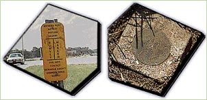
The "Witness Sign" and the "Control Monument" represent a sample of the County's Horizontal Control Network. There are several hundred of these Control Monuments established as inter visible pairs, at random locations throughout Seminole County. They have been established at a considerable amount of time and expense to Seminole County. They serve numerous purposes, such as for G.I.S. Mapping, Local Subdivision Development, Geodetic Control for Private Surveying Firms as well as other Government agencies. The preservation of these Control Monuments is important to the overall quality of the network as we continue to enlarge the control network. We ask that anyone noticing the "Witness Sign" indicating a nearby Seminole County Control Point, to not disturb that area. If this is not possible, please contact the Seminole County Survey Section at 407-665-5647, prior to excavation. You may also note that these points DO NOT represent any property boundary or property corner, they are merely random points that have precise latitude and longitude values measured to them.
Interactive Benchmark Map And Downloadable Survey Data:
Request Information
![]() Seminole County Survey Information Request Form. Fill in necessary information on the form and submit electronically in order to request survey information.
Seminole County Survey Information Request Form. Fill in necessary information on the form and submit electronically in order to request survey information.
Labins
The Land Boundary Information System includes Certified Corner Records, NGS Vertical and Horizontal Control Points, GLO Notes and more.
